 |
|
|
Three-Bay Sunday |
|
April 2009 Beaks and Bills
Three-Bay Sunday by Joe Meche Joe Meche is president of the North Cascades Audubon Society and also serves the chapter as newsletter editor and birding programs coordinator. He has been watching birds for over 50 years and photographing birds and landscapes for more than 30 years. The northern expanse of Puget Sound boasts some of the most spectacular bird watching in the entire country between November and April. The moderate temperatures and protected inland waters provide ideal winter habitats for numerous species of birds to feed and rest. Tens of thousands of resident and migratory birds have relied on this typically ice-free area for much longer than humans have been around and altering the landscape of these traditional wintering grounds. The birds still return and spend time here building their fat reserves throughout the colder months while preparing to return to their northern breeding grounds in spring. Many bird watchers and field trip groups that come from the greater Seattle area and even from out of state focus their energies on this particular area — and they’re never disappointed. When you’re watching birds, large numbers of any species are always impressive, and this is usually what you get when you visit the lowland haunts and flats that are adjacent to three northern bays of Washington state — Skagit, Padilla and Samish. These hotspots are common knowledge among local birders. For some, one of the main attractions of this three-bay area is the large concentration of birds of prey. It’s not unusual for birders to experience a five-falcon day on the flats and mid-February is the time for the annual Skagit Flats Winter Hawk Count. The area covered by the count actually encompasses the Samish Flats as well and is hosted by the Falcon Research Group, which is based in Bow, Washington. For a comprehensive overview of the results of the count and the ongoing Southern Cross Peregrine Project, visit their Web site at http://frg.org. Cindy and I chose to celebrate our anniversary (February 29) on March 1 by taking on a three-bay day. It was a little late in the year for the peak numbers of birds that you can expect in these Puget Sound locales, but it was just too nice a day not to have a look. We left home at the usual crack-of-dawn starting time, which translates to whatever time it is when we leave and grab a cup for the road (it’s an easy enough habit to fall into). These three Washington bays can be navigated quite easily by boat since the Swinomish Channel connects Skagit and Padilla Bays and the open waters of Padilla give way to Samish Bay, just past Wilson Point on Samish Island. However, if you don’t have the luxury of suitable watercraft with adequate means of propulsion, your motor vehicle will work just as well for traveling on back roads. A good way to expedite the travel time is to start on the south end of Skagit Bay which is easily accessible from Stanwood. Once you’re off the freeway, the pace slows significantly, all the way back to Chuckanut. But, let’s not get ahead of ourselves — we’ve only just begun. Starting Point in Stanwood
From the starting point in Stanwood, travel along Highway 530 to Conway. Cross the bridge and you’ll be on Fir Island, which lies between the North and South Forks of the Skagit River. If you take a left off Fir Island Road onto Mann Road and follow it to its end, you’ll find the perfect place to park in the heart of the Skagit Wildlife Area. Whenever you’re on Fir Island during this time of year, scan for large concentrations of whiteness — snow geese or swans. Grab your gear and take off on foot to explore and bird along the extensive dike system that follows the South Fork into the expansive wetlands that border on Skagit Bay. Fir Island hosts some of western Washington’s largest concentrations of snow geese and swans, and the accompanying large numbers of raptors and shorebirds on the Skagit Flats draw birders from far and wide. When you return to your vehicle, go back to Fir Island Road and head toward La Conner. Again, keep an eye out for ribbons of white in the fields. We found the main concentration of about 10,000 snow geese at the end of Rawlins Road. They were feeding actively and seemed to be content to be a bit farther off the main road. Most of us can probably relate to that feeling. When you reach Highway 20, turn left and head for the big bridge and your first views of Padilla Bay. This bay encompasses an area that is bounded by an assortment of human activities, including agricultural lands and refineries. The juxtaposition of these diverse uses might appear to be incompatible but somehow they seem to work. Refinery operations occupy the peninsula that is March Point, but a perimeter road follows the shoreline and is open to the public. The point is a great place to set up your scope and glass the expanse of the southern part of the bay and across the water to the state park at Bay View and the Padilla Bay Reserve. The waters on the March Point side of the bay are deeper and provide good looks at diving species like scoters, loons, goldeneyes and cormorants. Drive east on Highway 20 and turn onto the Bayview Edison Road to head north along the eastern shoreline of Padilla Bay. The Padilla Bay Shore Trail provides another opportunity to stretch your legs and possibly locate a few good shorebirds along Indian Slough. After watching for raptors along the way, you will drive through the community of Bay View, past the Bay View State Park — a good campground for extended stays — and then to the heart of the Padilla Bay National Estuarine Research Reserve. This reserve is managed cooperatively by the National Oceanic and Atmospheric Administration (NOAA) and the Washington state Department of Ecology (DOE) and is part of the larger National Estuarine Reserve System. The system is a network of protected areas established for long-term research, education and stewardship. While NOAA and DOE manage the reserve, the Padilla Bay Foundation supports the reserve and operates the Breazeale Interpretive Center. The center is a good place to stop to learn more about the reserve and stretch your legs with a walk around the grounds. This is usually a good place to look for passerine species in the nearby woods. A short handicap-accessible, all-weather pathway also leads underneath the road to a perfect observation platform where you can scope the bay for the birds you might have missed from March Point. There always seems to be a point-counterpoint discussion as to the proper pronunciation of Padilla. Some say Pah-dill-ah and it sounds like vanilla, while others say Pah-dee-ah, which sounds like tortilla. If you consider that the early Spanish explorers who roamed the area in the 1790s named the bay after the Viceroy of Mexico, you might opt for the latter. Nonetheless, you might say Pah-dill-ah while I say Pah-dee-ah, but it’s all about the birds. Samish Flats and Samish Bay
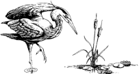
After traveling north from the reserve, you will come to a “T” in the road and find yourself in the middle of one of Washington’s premiere locations for wintering raptors. This area is known collectively as the Samish Flats. These flats are often the target area for birders seeking the five-falcon bonanza. In additions to falcons, short-eared owls and northern harriers can be observed in impressive numbers. From the flats, Samish Island awaits. The landform known as Samish Island now appears more like a peninsula that separates the waters of the adjoining Padilla and Samish Bays. In the late 1800s, a slough or salt marsh separated the island from the mainland. Extensive dikes and drainage ditches were built to increase the amount of farmland and provide a dry connection to the island. From many viewpoints on Samish Island, you can scope the expanse of Samish Bay to the north and east. Samish Bay sits on the northern edge of Skagit County and is home to some of America’s largest oyster farms, as well as attendant bird species such as gulls and herons. Incredible numbers of great blue herons prowl the shallows in the spring, especially when there are nestlings to be fed. On one bird count in May, I personally observed 275 great blues. After spending the day squinting through your binoculars and into your scopes for positive IDs and that occasional rarity, your last stop before heading for home via Chuckanut Drive could well be the Rhododendron Café in Bow. Your scenic drive home will be more enjoyable and unhurried by hunger. As you ascend the Chuckanut headlands, you can look back on your day, literally and figuratively. As important as it is to know where you’re going, it’s equally important to know where you’ve been. § |